


R1T-JG-25 bosses

Jack-94
User
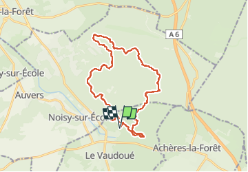

Length
17.1 km

Max alt
122 m

Uphill gradient
408 m
Km-Effort
23 km

Min alt
71 m

Downhill gradient
408 m
Boucle
Yes
Creation date :
2022-09-25 06:52:37.649
Updated on :
2022-10-03 20:48:42.53
8h25
Difficulty : Very difficult

FREE GPS app for hiking
 SityTrail
IGN / Geographical institutes
SityTrail Plus
The world is yours!
About
Trail Walking of 17.1 km to be discovered at Ile-de-France, Seine-et-Marne, Le Vaudoué. This trail is proposed by Jack-94.

Positioning
Country:
France
Region :
Ile-de-France
Department/Province :
Seine-et-Marne
Municipality :
Le Vaudoué
Location:
Unknown
Start:(Dec)
Start:(UTM)
464961 ; 5356857 (31U) N.
Comments